Earth - Gemini 5

Central Afghanistan, Northwest of Qandahar, on Earth

Earth
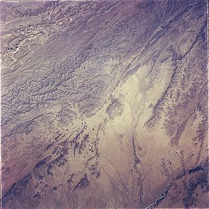
Gemini 5 photograph of the region of central Afghanistan northwest of Qandahar. The Helmand River and Kajakai Reservoir are in the lower right corner. Linear ridges visible at upper left are composed of folded sedimentary rock. North is at about 1:00. The image is about 300 km across. (Gemini 5, S65-45729 )

Earth
Earth Geology, Tectonics, Seismicity
Erosion

Full resolution size: 291K

Location & Time Information
Date/Time (UT): 1965-08-22 T 06:36
Distance/Range (km): N/A
Central Latitude/Longitude (deg): +33./295.
Orbit(s): 11

Imaging Information
Area or Feature Type: mountain, water, ridge
Instrument: Hasselblad 70-mm camera
Instrument Resolution (pixels): N/A
Instrument Field of View (deg): N/A
Filter: haze
Illumination Incidence Angle (deg): N/A
Phase Angle (deg): N/A
Instrument Look Direction: N/A
Surface Emission Angle (deg): N/A

Ordering Information
CD-ROM Volume: N/A
NASA Image ID number: S65-45729
Other Image ID number: S65-45487 (b&w)
NSSDC Data Set ID (Photo): 65-068A-02A
NSSDC Data Set ID (CD): N/A
Other ID: N/A

NSSDC LOGO

Autogen 1.1: Updated: Monday, 26-Aug-1996 08:52:28 EDT, GJM. NASA Official: Dr. Joseph H. King, Head, NSSDC.