Earth - Galileo
Raw image of Earth showing Antarctica and Africa
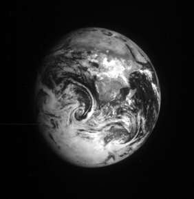
Galileo raw image of Earth taken from 2.7 million km
3 days after the first flyby. Africa and the Middle
East can be seen at the top and Antarctica at the bottom.
Weather systems are visible in the clouds over the
Atlantic and Indian oceans. The image was taken
through the infrared (9680 nm) filter, which enhances
the visibility of the land masses. Earth is 12,750 km
in diameter.
(Galileo, 00615203.00)
Earth
Galileo Mission
