 A
Virtual Tour of Mars
A
Virtual Tour of Mars
 A
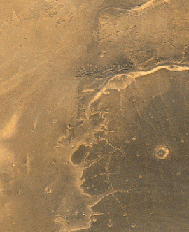
partial view of Lunae Planum (darker area on right side of image). In the top
right quarter of the image the upper reaches of the Kasei Vallis channel system
can be seen. Mass wasting and flow features are prominent. The flow features
indicate ancient flow directions to be from the lower left towards the upper
right.
A
partial view of Lunae Planum (darker area on right side of image). In the top
right quarter of the image the upper reaches of the Kasei Vallis channel system
can be seen. Mass wasting and flow features are prominent. The flow features
indicate ancient flow directions to be from the lower left towards the upper
right.
 More
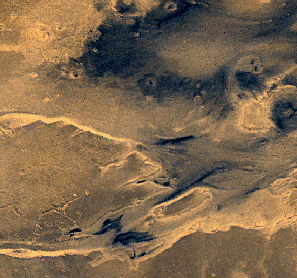
of the Kasei Vallis system. Flow features indicate flow from left to right.
The Shoronov Crater can be seen along the right edge of the image.
More
of the Kasei Vallis system. Flow features indicate flow from left to right.
The Shoronov Crater can be seen along the right edge of the image.
 The
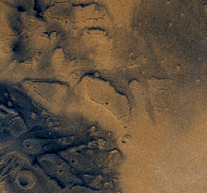
lower reaches of the Kasei Vallis channel system. The lighter area at lower
right is northwestern Chryse Planitia; the landing site of the Viking 1 lander
on July 20, 1976. The darker area at upper right is southern Acidalia Planitia.
The
lower reaches of the Kasei Vallis channel system. The lighter area at lower
right is northwestern Chryse Planitia; the landing site of the Viking 1 lander
on July 20, 1976. The darker area at upper right is southern Acidalia Planitia.
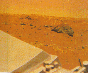 A view of Chryse
Planitia from the Viking 1 lander.
A view of Chryse
Planitia from the Viking 1 lander.
 Mars
Home
Mars
Home
NSSDCA
Planetary Science Homepage
NSSDCA
Homepage
NASA
Homepage
NSSDCA
Search
Questions and comments about this page should be addressed to:
Dr. David R. Williams, david.r.williams@nasa.gov,
(301) 286-1258
NSSDCA, Mail Code 690.1, NASA/Goddard Space Flight Center, Greenbelt, MD 20771

Page Author: Malcolm J. Shaw, Malcolm_Shaw@pcp.ca
NASA Official: Dr. Ed Grayzeck, edwin.j.grayzeck@nasa.gov
Last Updated: 20 March 2001, DRW